


A20 - Sun Valley
Located in Bullhead City, United States
ICAO - A20, IATA -
Data provided by AirmateGeneral information
Coordinates: N35°0'20" W114°33'54"
Elevation is 725 feet MSL.
Magnetic variation is 14° East View others Airports in Arizona
Operational data
Special qualification required
Current time UTC:
Current local time:
Communications frequencies: [VIEW]
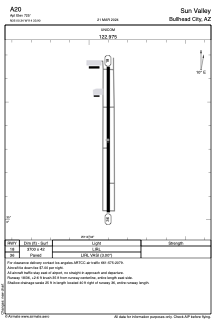
Runways:
| RWY identifier | QFU | Length (ft) | Width (ft) | Surface | LDA (ft) |
| 18 | 0° | 3700 | 42 | ASPH | |
| 36 | 0° | 3700 | 42 | ASPH |
Airport contact information
Address: Bullhead City United States