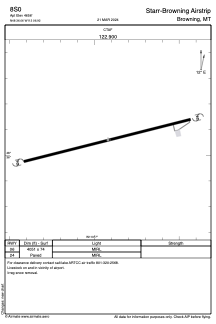


8S0 - Starr-Browning Airstrip
Located in Browning, United States
ICAO - 8S0, IATA -
Data provided by AirmateGeneral information
Coordinates: N48°36'4" W113°6'55"
Elevation is 4657 feet MSL.
Magnetic variation is 18° East View others Airports in Montana
Operational data
Special qualification required
Current time UTC:
Current local time:
Weather at : KCTB - Cut Bank Intl ( 54 km )
METAR: KCTB 170056Z AUTO 34014KT 10SM CLR 12/M01 A2986 RMK AO2 SLP109 T01171006
TAF: KCTB 162320Z 1700/1724 33017G24KT P6SM BKN050 FM170100 31011KT P6SM SCT050 BKN080 TEMPO 1701/1704 -SHRA BKN050 FM170700 33005KT P6SM BKN045 FM171600 35008KT P6SM -SHRA BKN035
Communications frequencies: [VIEW]
Runways:
| RWY identifier | QFU | Length (ft) | Width (ft) | Surface | LDA (ft) |
| 06 | 0° | 4051 | 74 | ASPH | |
| 24 | 0° | 4051 | 74 | ASPH |
Airport contact information
Address: Browning United States