


81D - Flyin Tiger
Located in Angleton, United States
ICAO - 81D, IATA -
Data provided by AirmateGeneral information
Coordinates: N29°15'54" W95°24'45"
Elevation is 30 feet MSL.
Magnetic variation is 06° East View others Airports in Texas
Operational data
Special qualification required
Current time UTC:
Current local time:
Communications frequencies: [VIEW]
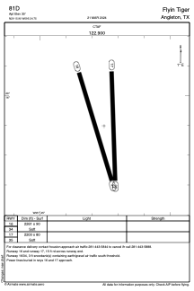
Runways:
| RWY identifier | QFU | Length (ft) | Width (ft) | Surface | LDA (ft) |
| 16 | 163° | 2261 | 90 | GRASS | |
| 34 | 343° | 2261 | 90 | GRASS | |
| 17 | 178° | 2200 | 80 | GRASS | |
| 35 | 358° | 2200 | 80 | GRASS |
Airport contact information
Address: Angleton United States