


79KY - Lucas Fld
Located in Nicholasville, United States
ICAO - 79KY, IATA -
Data provided by AirmateGeneral information
Coordinates: N37°52'17" W84°36'38"
Elevation is 906 feet MSL.
Magnetic variation is -05° East View others Airports in Kentucky
Operational data
Special qualification required
Current time UTC:
Current local time:
Weather at : KLEX - Blue Grass ( 18 km )
METAR: KLEX 041854Z 00000KT 8SM -TSRA SCT030 BKN060 BKN075 24/20 A2986 RMK AO2 LTG DSNT SW AND W RAB25 TSB25 SLP104 P0063 T02390200
TAF: KLEX 041720Z 0418/0518 19005KT P6SM VCTS BKN035CB TEMPO 0418/0421 19008G20KT 4SM -TSRA BR FM042100 20008KT P6SM VCTS BKN040CB FM050100 16005KT P6SM BKN050
Communications frequencies: [VIEW]
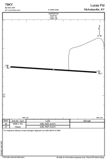
Runways:
| RWY identifier | QFU | Length (ft) | Width (ft) | Surface | LDA (ft) |
| 09 | 0° | 5488 | 100 | CONC | |
| 27 | 0° | 5488 | 100 | CONC |
Airport contact information
Address: Nicholasville United States