


70D - Titus Fld
Located in Arthurdale, United States
ICAO - 70D, IATA -
Data provided by AirmateGeneral information
Coordinates: N39°29'56" W79°51'11"
Elevation is 1863 feet MSL.
Magnetic variation is -07° East View others Airports in West Virginia
Operational data
Special qualification required
Current time UTC:
Current local time:
Weather at : KMGW - Morgantown Muni/Walter L Bill Hart Fld ( 17 km )
METAR: KMGW 111453Z 01005KT 10SM BKN026 17/09 A3004 RMK AO2 SLP169 T01670089 51013 $
TAF: KMGW 111408Z 1114/1212 VRB02KT P6SM SCT020 TEMPO 1114/1115 BKN025 FM111500 32004KT P6SM FEW080
Communications frequencies: [VIEW]
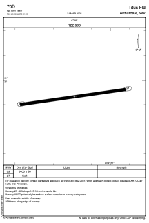
Runways:
| RWY identifier | QFU | Length (ft) | Width (ft) | Surface | LDA (ft) |
| 09 | 82° | 2400 | 50 | GRASS | |
| 27 | 262° | 2400 | 50 | GRASS |
Airport contact information
Address: Arthurdale United States