


56D - Wyandot County
Located in Upper Sandusky, United States
ICAO - 56D, IATA -
Data provided by AirmateGeneral information
Coordinates: N40°53'0" W83°18'52"
Elevation is 830 feet MSL.
Magnetic variation is -05° East View others Airports in Ohio
Operational data
Special qualification required
Current time UTC:
Current local time:
Weather at : KFDY - Findlay ( 33 km )
METAR: KFDY 021838Z AUTO 27007KT 10SM SCT024 BKN029 OVC075 23/17 A2994 RMK AO2 T02330172
TAF: KFDY 021750Z 0218/0318 27007KT P6SM VCSH BKN025 TEMPO 0218/0220 5SM -SHRA FM030200 18003KT P6SM SCT030 FM030700 VRB02KT 3SM BR SCT015 FM031000 VRB02KT 1SM BR SCT002 TEMPO 0310/0313 1/2SM FG OVC002 FM031400 21005KT P6SM BKN015 FM031600 20006KT P6SM SCT030
Communications frequencies: [VIEW]
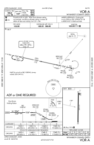
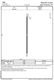
Runways:
| RWY identifier | QFU | Length (ft) | Width (ft) | Surface | LDA (ft) |
| 18 | 180° | 3997 | 75 | ASPH | |
| 36 | 0° | 3997 | 75 | ASPH |
Airport contact information
Address: Upper Sandusky United States