


53K - Osage City Muni
Located in Osage City, United States
ICAO - 53K, IATA -
Data provided by AirmateGeneral information
Coordinates: N38°38'1" W95°48'7"
Elevation is 1105 feet MSL.
Magnetic variation is 06° East View others Airports in Kansas
Operational data
Special qualification required
Current time UTC:
Current local time:
Communications frequencies: [VIEW]
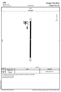
Runways:
| RWY identifier | QFU | Length (ft) | Width (ft) | Surface | LDA (ft) |
| 17 | 180° | 2539 | 40 | ASPH | |
| 35 | 0° | 2539 | 40 | ASPH |
Airport contact information
Address: Osage City United States