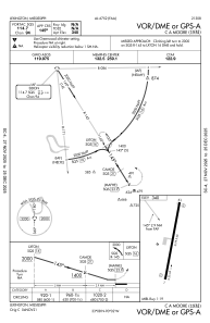
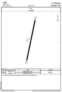


19M - C A Moore
Located in Lexington, United States
ICAO - 19M, IATA -
Data provided by AirmateGeneral information
Coordinates: N33°7'32" W90°1'32"
Elevation is 340 feet MSL.
Magnetic variation is 02° East View others Airports in Mississippi
Operational data
Special qualification required
Current time UTC:
Current local time:
Communications frequencies: [VIEW]
Runways:
| RWY identifier | QFU | Length (ft) | Width (ft) | Surface | LDA (ft) |
| 01 | 12° | 3199 | 60 | ASPH | |
| 19 | 192° | 3199 | 60 | ASPH |
Airport contact information
Address: Lexington United States