


16J - Dawson Muni
Located in Dawson, United States
ICAO - 16J, IATA -
Data provided by AirmateGeneral information
Coordinates: N31°44'36" W84°25'9"
Elevation is 332 feet MSL.
Magnetic variation is -02° East View others Airports in Georgia
Operational data
Special qualification required
Current time UTC:
Current local time:
Weather at : KABY - Southwest Georgia Rgnl ( 31 km )
METAR: KABY 161853Z 10011G18KT 10SM FEW055 36/19 A3004 RMK AO2 SLP171 T03560194
TAF: KABY 161721Z 1618/1718 12007KT P6SM SCT045 FM162300 13009KT P6SM VCTS SCT050CB FM170300 15004KT P6SM SCT100
Communications frequencies: [VIEW]
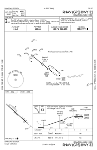
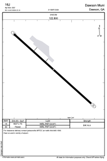
Runways:
| RWY identifier | QFU | Length (ft) | Width (ft) | Surface | LDA (ft) |
| 14 | 132° | 4507 | 75 | ASPH | |
| 32 | 312° | 4507 | 75 | ASPH |
Airport contact information
Address: Dawson United States
