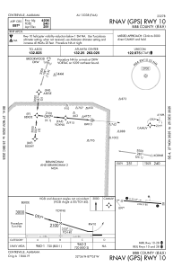
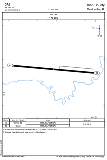


0A8 - Bibb County
Located in Centreville, United States
ICAO - 0A8, IATA -
Data provided by AirmateGeneral information
Coordinates: N32°56'13" W87°5'26"
Elevation is 251 feet MSL.
Magnetic variation is -02° East View others Airports in Alabama
Operational data
Special qualification required
Current time UTC:
Current local time:
Communications frequencies: [VIEW]
Runways:
| RWY identifier | QFU | Length (ft) | Width (ft) | Surface | LDA (ft) |
| 10 | 95° | 4206 | 80 | ASPH | |
| 28 | 275° | 4206 | 80 | ASPH |
Airport contact information
Address: Centreville United States