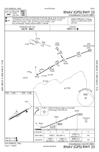
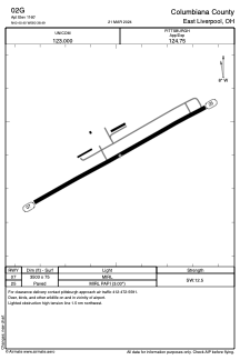


02G - Columbiana County
Located in East Liverpool, United States
ICAO - 02G, IATA -
Data provided by AirmateGeneral information
Coordinates: N40°40'24" W80°38'29"
Elevation is 1161 feet MSL.
Magnetic variation is -08° East View others Airports in Ohio
Operational data
Special qualification required
Current time UTC:
Current local time:
Weather at : KBVI - Beaver County ( 24 km )
METAR: KBVI 042035Z AUTO 00000KT 10SM CLR 30/15 A2990 RMK AO2 T03000148
TAF: KBVI 041722Z 0418/0518 15004KT P6SM SCT040 BKN150 FM051500 18007KT P6SM VCTS BKN050CB
Communications frequencies: [VIEW]
Runways:
| RWY identifier | QFU | Length (ft) | Width (ft) | Surface | LDA (ft) |
| 07 | 61° | 3503 | 75 | ASPH | |
| 25 | 241° | 3503 | 75 | ASPH |
Airport contact information
Address: East Liverpool United States