


YWAG - Wanaaring
Located in Wanaaring, Australia
ICAO - YWAG, IATA -
Data provided by AirmateGeneral information
Coordinates: S29°42'42" E144°10'16"
Elevation is 360 feet MSL.
Magnetic variation is 9° East View others Airports in New South Wales
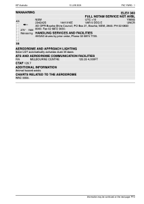
Operational data
Special qualification required
Current time UTC:
Current local time:
Weather at : - ( 0 km )
METAR: ZMUB 200600Z 28006G11MPS 250V310 9999 FEW033 SCT100 16/M03 Q1000 NOSIG RMK QFE644.5 27 MOP
Communications frequencies: [VIEW]
Runways:
| RWY identifier | QFU | Length (ft) | Width (ft) | Surface | LDA (ft) |
| 17 | 0° | 3608 | 0 | B | |
| 35 | 0° | 3608 | 0 | B |
Airport contact information
Address: Wanaaring Australia