


YRID - Riddell
Located in Riddell's Creek, Australia
ICAO - YRID, IATA -
Data provided by AirmateGeneral information
Coordinates: S37°28'41" E144°43'18"
Elevation is 1155 feet MSL.
Magnetic variation is 11° East View others Airports in Victoria
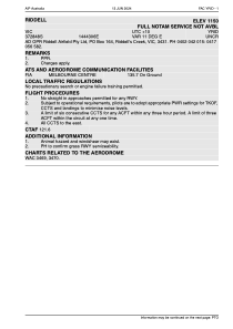
Operational data
Special qualification required
Current time UTC:
Current local time:
Weather at : YMML - Melbourne ( 24 km )
TAF: TAF YMML 240810Z 2409/2512 24010KT 9999 SCT040 FM241200 28008KT 9999 BKN040 FM241500 26008KT 9999 SCT025 BKN040 FM250100 22014KT 9999 -SHRA SCT030 BKN040 FM250900 24008KT 9999 NSW SCT035
Communications frequencies: [VIEW]
Runways:
| RWY identifier | QFU | Length (ft) | Width (ft) | Surface | LDA (ft) |
| 02 | 31° | 2686 | 28 | ASPH | |
| 20 | 211° | 2686 | 28 | ASPH |
Airport contact information
Address: Riddell's Creek Australia