


YPKU - Kununurra
Located in Kununurra, Australia
ICAO - YPKU, IATA - KNX
Data provided by AirmateGeneral information
Coordinates: S15°46'41" E128°42'27"
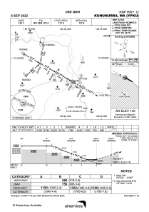
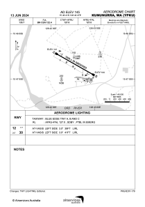
Elevation is 145 feet MSL.
View others Airports in Western Australia
Operational data
Special qualification required
Current time UTC:
Current local time:
Weather
METAR: YPKU 180300Z AUTO 12015KT 9999 // NCD 33/17 Q1012 RF00.0/000.0
TAF: TAF YPKU 180104Z 1802/1814 12014KT CAVOK FM181000 16005KT CAVOK
Communications frequencies: [VIEW]
Runways:
| RWY identifier | QFU | Length (ft) | Width (ft) | Surface | LDA (ft) |
| 12 | 120° | 6001 | 98 | ASP | |
| 30 | 300° | 6001 | 98 | ASP |
Airport contact information
Address: Kununurra Australia
Other aviation service providers
Flight schools

Australian Helicopter Academy
Australian Helicopter Academy
admin@australianhelicopteracademy.com.au+61891681110