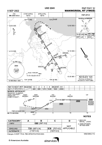
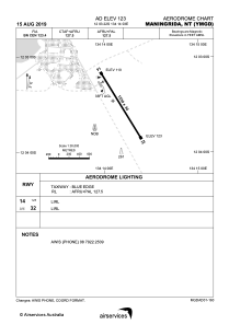


YMGD - Maningrida
Located in Maningrida, Australia
ICAO - YMGD, IATA - MNG
Data provided by AirmateGeneral information
Coordinates: S12°3'22" E134°14'3"
Elevation is 123 feet MSL.
View others Airports in Northern Territory
Operational data
Special qualification required
Current time UTC:
Current local time:
Communications frequencies: [VIEW]
Runways:
| RWY identifier | QFU | Length (ft) | Width (ft) | Surface | LDA (ft) |
| 14 | 149° | 5020 | 98 | ASP | |
| 32 | 329° | 5020 | 98 | ASP |
Airport contact information
Address: Maningrida Australia