


YGNW - Gnowangerup
Located in Gnowangerup, Australia
ICAO - YGNW, IATA -
Data provided by AirmateGeneral information
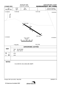
Coordinates: S33°58'42" E118°0'46"
Elevation is 920 feet MSL.
Magnetic variation is -1° East View others Airports in Western Australia
Operational data
Special qualification required
Current time UTC:
Current local time:
Communications frequencies: [VIEW]
Runways:
| RWY identifier | QFU | Length (ft) | Width (ft) | Surface | LDA (ft) |
| 12 | 122° | 4918 | 98 | X | |
| 30 | 302° | 4918 | 98 | X |
Airport contact information
Address: Gnowangerup Australia