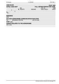


YGIB - Gibb River
Located in Gibb, Australia
ICAO - YGIB, IATA - GBV
Data provided by AirmateGeneral information
Coordinates: S16°25'7" E126°26'44"
Elevation is 1669 feet MSL.
Magnetic variation is 2° East View others Airports in Western Australia
Operational data
Special qualification required
Current time UTC:
Current local time:
Weather at : - ( 0 km )
METAR: PAPH 200531Z AUTO 13010KT 10SM -RA BKN023 03/02 A2972 RMK AO2 P0001 $
Communications frequencies: [VIEW]
Runways:
| RWY identifier | QFU | Length (ft) | Width (ft) | Surface | LDA (ft) |
| 07 | 0° | 3497 | 98 | N | |
| 25 | 0° | 3497 | 98 | N |
Airport contact information
Address: Gibb Australia