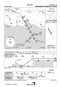
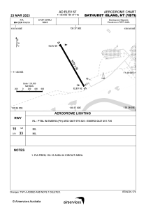


YBTI - Bathurst Island
Located in Bathurst Island, Australia
ICAO - YBTI, IATA - BRT
Data provided by AirmateGeneral information
Coordinates: S11°46'9" E130°37'11"
Elevation is 67 feet MSL.
View others Airports in Northern Territory
Operational data
Special qualification required
Current time UTC:
Current local time:
Weather at : YPDN - Darwin ( 77 km )
METAR: YPDN 250400Z 09015KT 9999 FEW042 34/22 Q1009
TAF: TAF YPDN 250206Z 2503/2606 10012KT 9999 SCT040 FM250600 05008KT 9999 SCT050 FM251200 10005KT 9999 SCT025 FM260000 10012KT 9999 SCT040 INTER 2512/2518 2000 SHRA BKN010 SCT025TCU PROB30 TEMPO 2512/2518 VRB20G35KT 1000 TSRA BKN008 SCT025CB
Communications frequencies: [VIEW]
Runways:
| RWY identifier | QFU | Length (ft) | Width (ft) | Surface | LDA (ft) |
| 15 | 150° | 4823 | 98 | ASP | |
| 33 | 330° | 4823 | 98 | ASP |
Airport contact information
Address: Bathurst Island Australia