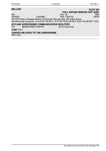


YBIU - Ballidu
Located in Wongan Hills, Australia
ICAO - YBIU, IATA -
Data provided by AirmateGeneral information
Coordinates: S30°35'33" E116°46'45"
Elevation is 950 feet MSL.
Magnetic variation is -1° East View others Airports in Victoria
Operational data
Special qualification required
Current time UTC:
Current local time:
Weather at : - ( 0 km )
METAR: CYSF 261604Z AUTO 32008KT 290V020 9SM -SN BKN021 BKN047 OVC060 M07/M11 A2985 RMK SLP132
Communications frequencies: [VIEW]
Runways:
| RWY identifier | QFU | Length (ft) | Width (ft) | Surface | LDA (ft) |
| 06 | 54° | 2599 | 122 | DIRT | |
| 24 | 234° | 2599 | 122 | DIRT | |
| 12 | 0° | 2493 | 0 | X | |
| 30 | 0° | 2493 | 0 | X | |
| 11 | 114° | 2821 | 140 | DIRT | |
| 29 | 294° | 2821 | 140 | DIRT |
Airport contact information
Address: Wongan Hills Australia