


Y14 - Marv Skie-Lincoln County
Located in Tea, United States
ICAO - Y14, IATA -
Data provided by AirmateGeneral information
Coordinates: N43°27'18" W96°48'5"
Elevation is 1511 feet MSL.
Magnetic variation is 06° East View others Airports in South Dakota
Operational data
Special qualification required
Current time UTC:
Current local time:
Weather at : KFSD - Joe Foss Fld ( 15 km )
METAR: KFSD 200156Z 14014G23KT 10SM -TSRA FEW019 SCT090CB BKN110 20/11 A2976 RMK AO2 RAB32 TSB36 SLP074 OCNL LTGIC OHD TS OHD MOV NE P0000 T02000111
TAF: KFSD 192320Z 2000/2024 14010G17KT P6SM BKN120 FM200200 15010KT P6SM VCSH BKN050 FM200600 16008KT P6SM OVC020 FM201100 25006KT P6SM OVC012 FM201400 32006KT P6SM SCT016
Communications frequencies: [VIEW]
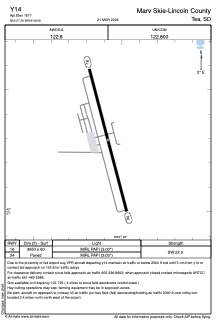
Runways:
| RWY identifier | QFU | Length (ft) | Width (ft) | Surface | LDA (ft) |
| 16 | 0° | 3650 | 60 | CONC | |
| 34 | 0° | 3650 | 60 | CONC |
Airport contact information
Address: Tea United States
