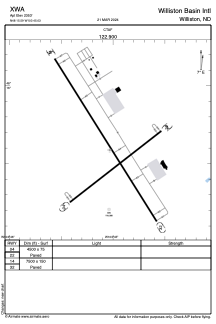


XWA - Williston Basin Intl
Located in Williston, United States
ICAO - XWA, IATA -
Data provided by AirmateGeneral information
Coordinates: N48°15'35" W103°45'2"
Elevation is 2353 feet MSL.
Magnetic variation is 08° East View others Airports in North Dakota
Operational data
Special qualification required
Current time UTC:
Current local time:
Weather at : KXWA - Williston Basin Intl ( 0 km )
METAR: KXWA 241151Z AUTO 18007KT 10SM CLR 03/M05 A3005 RMK AO2 SLP193 T00281050 10067 20017 58006
TAF: KXWA 241122Z 2412/2512 17007KT P6SM FEW200 FM241600 16014KT P6SM BKN200 FM250100 13014KT P6SM FEW200 FM250700 16008KT P6SM FEW200
Communications frequencies: [VIEW]
Runways:
Airport contact information
Address: Williston United States