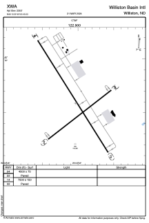


XWA - Williston Basin Intl
Located in Williston, United States
ICAO - XWA, IATA -
Data provided by AirmateGeneral information
Coordinates: N48°15'35" W103°45'2"
Elevation is 2353 feet MSL.
Magnetic variation is 08° East View others Airports in North Dakota
Operational data
Special qualification required
Current time UTC:
Current local time:
Weather at : KXWA - Williston Basin Intl ( 0 km )
METAR: KXWA 030451Z AUTO 29012KT 10SM OVC011 04/03 A2974 RMK AO2 SLP089 T00440033
TAF: KXWA 030353Z 0304/0324 29015G25KT P6SM SCT014 BKN020 FM030900 28015KT 6SM -SHRA BR BKN008 FM031500 30015KT P6SM VCSH OVC007 FM031800 30016KT P6SM VCSH BKN015
Communications frequencies: [VIEW]
Runways:
Airport contact information
Address: Williston United States