
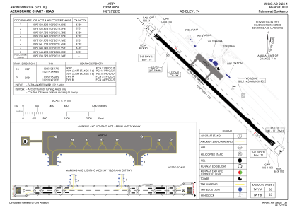


WIGG - Bengkulu/Fatmawati Soekarno
Located in Bengkulu, Indonesia
ICAO - , IATA - BKS
Data provided by AirmateGeneral information
Coordinates: S3°51'40" E102°20'22"
Elevation is 74 feet MSL.
View others Airports in Bengkulu
Operational data
Special qualification required
Current time UTC:
Current local time:
Weather at : - ( 0 km )
METAR: UAAA 241227Z 24015G20MPS 9999 VCTS SQ SCT050CB BKN100 18/12 Q1014 TEMPO VRB17MPS 3000 TSRA SQ
Communications frequencies: [VIEW]
Runways:
| RWY identifier | QFU | Length (ft) | Width (ft) | Surface | LDA (ft) |
| 13 | 133° | 7382 | 148 | UNK | |
| 31 | 313° | 7382 | 148 | UNK |
Airport contact information
Address: Bengkulu Indonesia