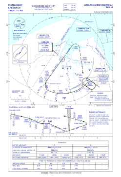


WBGJ - Limbang
Located in Limbang, Malaysia
ICAO - WBGJ, IATA - LMN
Data provided by AirmateGeneral information
Coordinates: N4°48'30" E115°0'34"
Elevation is 15 feet MSL.
View others Airports in Sarawak
Operational data
Special qualification required
Current time UTC:
Current local time:
Weather at : WBSB - Brunei / International ( 18 km )
METAR: WBSB 251700Z 11003KT 9999 FEW015 BKN300 28/27 Q1008 NOSIG
TAF: TAF WBSB 251700Z 2518/2700 20003KT 9999 FEW015 BECMG 2603/2605 30010KT SCT015 FEW016CB
Communications frequencies: [VIEW]
Runways:
| RWY identifier | QFU | Length (ft) | Width (ft) | Surface | LDA (ft) |
| 04 | 37° | 4921 | 98 | ASP | |
| 22 | 217° | 4921 | 98 | ASP |
Airport contact information
Address: Limbang Malaysia