


WATR - Rote Ndao / David Constantijn Saudale
Located in Namodale, Indonesia
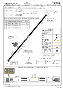
ICAO - , IATA - RTI
Data provided by AirmateGeneral information
Coordinates: S10°46'1" E123°4'27"
Elevation is 465 feet MSL.
Magnetic variation is 1° East View others Airports in Nusa Tenggara Timur
Operational data
Special qualification required
Current time UTC:
Current local time:
Weather at : - ( 0 km )
METAR: PFKT 182356Z AUTO 24014KT 10SM OVC010 M07/M10 A3006 RMK AO2 SNE19 SLPNO P0000 6//// T10721100 FZRANO
Communications frequencies: [VIEW]
Runways:
| RWY identifier | QFU | Length (ft) | Width (ft) | Surface | LDA (ft) |
| 04 | 41° | 5413 | 98 | UNK | |
| 22 | 221° | 5413 | 98 | UNK | |
| 04 | 0° | 0 | 0 | ASPH | |
| 22 | 0° | 0 | 0 | ASPH |
Airport contact information
Address: Namodale Indonesia