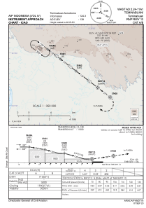
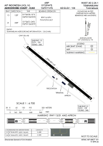


WAST - Teminabuan / Teminabuan
Located in Teminabuan, Indonesia
ICAO - WAST, IATA - TXM
Data provided by AirmateGeneral information
Coordinates: S1°26'40" E132°1'12"
Elevation is 144 feet MSL.
Magnetic variation is 1° East View others Airports in Irian Jaya
Operational data
Special qualification required
Current time UTC:
Current local time:
Weather at : - ( 0 km )
METAR: PAJZ 252021Z AUTO 13009KT 10SM -RA FEW022 BKN030 OVC037 04/03 A2988 RMK AO2 RAB18 P0000 $
Communications frequencies: [VIEW]
Runways:
| RWY identifier | QFU | Length (ft) | Width (ft) | Surface | LDA (ft) |
| 13 | 129° | 2625 | 75 | UNK | |
| 31 | 309° | 2625 | 75 | UNK |
Airport contact information
Address: Teminabuan Indonesia