


WAJS - Keerom / Senggeh
Located in , Indonesia
ICAO - WAJS, IATA - SEH
Data provided by AirmateGeneral information
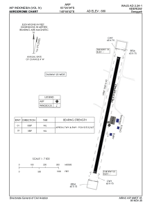
Coordinates: S3°26'34" E140°46'42"
Elevation is 680 feet MSL.
View others Airports in Papua
Operational data
Special qualification required
Current time UTC:
Current local time:
Weather at : - ( 0 km )
METAR: OPLA 191025Z 24020KT 5000 HZ SCT040 SCT100 31/18 Q1000 TEMPO 23025G45KT 2000 TSRA FEW030CB RMK QFE975 A29.55
Communications frequencies: [VIEW]
Runways:
| RWY identifier | QFU | Length (ft) | Width (ft) | Surface | LDA (ft) |
| 01 | 11° | 2953 | 75 | UNK | |
| 19 | 191° | 2953 | 75 | UNK |
Airport contact information
Address: Indonesia