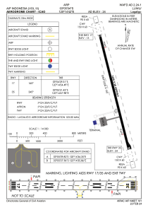


WAFD - Luwu / Bua
Located in Palopo, Indonesia
ICAO - , IATA -
Data provided by AirmateGeneral information
Coordinates: S3°5'4" E120°14'42"
Elevation is 24 feet MSL.
View others Airports in Sulawesi Selatan
Operational data
Special qualification required
Current time UTC:
Current local time:
Weather at : - ( 0 km )
METAR: RCSS 250632Z 29007KT 9999 FEW020 BKN035 BKN050 27/23 Q1008 NOSIG RMK 29009KT/R10 A2978
Communications frequencies: [VIEW]
Runways:
| RWY identifier | QFU | Length (ft) | Width (ft) | Surface | LDA (ft) |
| 17 | 165° | 5413 | 98 | UNK | |
| 35 | 345° | 5413 | 98 | UNK |
Airport contact information
Address: Palopo Indonesia