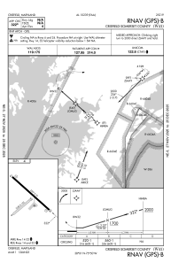


W41 - Crisfield-Somerset County
Located in Crisfield, United States
ICAO - W41, IATA -
Data provided by AirmateGeneral information
Coordinates: N38°1'5" W75°49'37"
Elevation is 4 feet MSL.
Magnetic variation is -10° East View others Airports in Maryland
Operational data
Special qualification required
Current time UTC:
Current local time:
Weather at : KTGI - Tangier Island ( 26 km )
METAR: KTGI 162155Z AUTO 19007KT 10SM CLR 18/11 A3015 RMK AO1 T01830106
Communications frequencies: [VIEW]
Runways:
| RWY identifier | QFU | Length (ft) | Width (ft) | Surface | LDA (ft) |
| 06 | 50° | 1060 | 120 | GRASS | |
| 24 | 230° | 1060 | 120 | GRASS | |
| 14 | 132° | 2397 | 75 | ASPH | |
| 32 | 312° | 2397 | 75 | ASPH |
Airport contact information
Address: Crisfield United States