


W20 - Moses Lake Muni
Located in Moses Lake, United States
ICAO - W20, IATA -
Data provided by AirmateGeneral information
Coordinates: N47°8'31" W119°14'16"
Elevation is 1205 feet MSL.
Magnetic variation is 19° East View others Airports in Washington
Operational data
Special qualification required
Current time UTC:
Current local time:
Weather at : KMWH - Grant County Intl ( 10 km )
METAR: KMWH 270252Z 21006KT 10SM BKN065 OVC100 17/04 A2982 RMK AO2 SLP098 T01670039 53008
TAF: KMWH 262320Z 2700/2724 21006KT P6SM BKN080 FM270300 19005KT P6SM SCT070 FM271200 19005KT P6SM BKN070 FM272100 21012KT P6SM BKN060 BKN120
Communications frequencies: [VIEW]
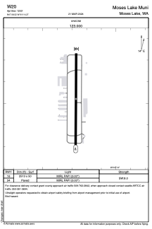
Runways:
| RWY identifier | QFU | Length (ft) | Width (ft) | Surface | LDA (ft) |
| 16 | 0° | 2513 | 50 | ASPH | |
| 34 | 0° | 2513 | 50 | ASPH |
Airport contact information
Address: Moses Lake United States
