


W16 - First Air Fld
Located in Monroe, United States
ICAO - W16, IATA -
Data provided by AirmateGeneral information
Coordinates: N47°52'17" W121°59'43"
Elevation is 50 feet MSL.
Magnetic variation is 20° East View others Airports in Washington
Operational data
Special qualification required
Current time UTC:
Current local time:
Weather at : KPAE - Snohomish County (Paine Fld) ( 22 km )
METAR: KPAE 251753Z 17012KT 8SM -RA SCT005 SCT042 OVC060 11/08 A2983 RMK AO2 SLP101 P0000 60014 T01110083 10117 20094 56004
TAF: KPAE 251725Z 2518/2618 19012KT 4SM -RA BKN005 OVC010 FM252100 18015G23KT 6SM -RA BR OVC015 FM260800 17012KT 4SM -RA BR OVC009
Communications frequencies: [VIEW]
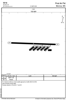
Runways:
| RWY identifier | QFU | Length (ft) | Width (ft) | Surface | LDA (ft) |
| 07 | 92° | 2087 | 34 | ASPH | |
| 25 | 272° | 2087 | 34 | ASPH |
Airport contact information
Address: Monroe United States
