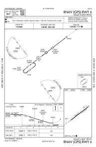


W13 - Eagle's Nest
Located in Waynesboro, United States
ICAO - W13, IATA -
Data provided by AirmateGeneral information
Coordinates: N38°4'37" W78°56'40"
Elevation is 1436 feet MSL.
Magnetic variation is -09° East View others Airports in Virginia
Operational data
Special qualification required
Current time UTC:
Current local time:
Weather at : KSHD - Shenandoah Valley Rgnl ( 21 km )
METAR: KSHD 231835Z AUTO 23010G19KT 10SM CLR 20/M01 A3006 RMK AO2 T02031006
Communications frequencies: [VIEW]
Runways:
| RWY identifier | QFU | Length (ft) | Width (ft) | Surface | LDA (ft) |
| 06 | 0° | 2004 | 50 | ASPH | |
| 24 | 0° | 2004 | 50 | ASPH |
Airport contact information
Address: Waynesboro United States
Other aviation service providers
Flight schools

Eagle's Nest Flight Services, Llc
Eagle's Nest Flight Services, Llc
jtrissel@eaglesnest.aero+1(540)943-4447