


VOML - Mangaluru International Airport, Mangaluru
Located in Mangaluru, India
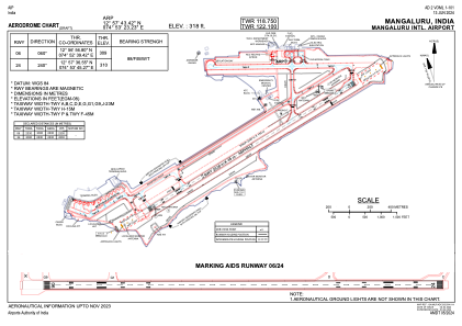
ICAO - VOML, IATA - IXE
Data provided by AirmateGeneral information
Coordinates: N12°57'43" E74°53'23"
Elevation is 320 feet MSL.
View others Airports in Karnataka
Operational data
Special qualification required
Current time UTC:
Current local time:
Communications frequencies: [VIEW]
Runways:
| RWY identifier | QFU | Length (ft) | Width (ft) | Surface | LDA (ft) |
| 06 | 58° | 7644 | 148 | UNK | |
| 24 | 238° | 7644 | 148 | UNK |
Airport contact information
Address: Mangaluru India