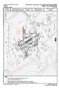
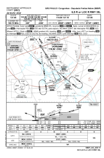
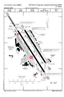


SBSP - São Paulo / Congonhas
Located in São Paulo / Congonhas, Brazil
ICAO - SBSP, IATA - CGH
Data provided by AirmateGeneral information
Coordinates: S23°37'34" W46°39'23"
Elevation is 2631 feet MSL.
Magnetic variation is -22.0° East View others Airports in São Paulo
Operational data
Special qualification required
Current time UTC:
Current local time:
Weather
METAR: SBSP 281700Z 30008KT 220V350 CAVOK 30/15 Q1016
TAF: TAF SBSP 281630Z 2818/2906 30010KT 9999 SCT030 TX30/2818Z TN20/2905Z BECMG 2819/2821 14005KT FEW030 BECMG 2822/2824 SCT020 BECMG 2901/2903 5000 BR BKN010 RMK PGL
Communications frequencies: [VIEW]
Runways:
| RWY identifier | QFU | Length (ft) | Width (ft) | Surface | LDA (ft) |
| 17R | 148° | 2060 | 280 | ASPH | |
| 35L | 328° | 2060 | 280 | ASPH | |
| 17L | 148° | 1615 | 150 | ASPH | |
| 35R | 328° | 1615 | 150 | ASPH |
Airport contact information
Address: São Paulo / Congonhas Brazil

