


SBNF - Navegantes / Ministro Victor Konder
Located in Navegantes / Ministro Victor Konder, Brazil
ICAO - SBNF, IATA - NVT
Data provided by AirmateGeneral information
Coordinates: S26°52'43" W48°39'3"
Elevation is 17 feet MSL.
Magnetic variation is -20.0° East View others Airports in Santa Catarina
Operational data
Special qualification required
Current time UTC:
Current local time:
Weather
METAR: SBNF 281000Z 15004KT 100V190 9999 SCT020 BKN100 23/22 Q1010
TAF: TAF SBNF 280900Z 2812/2912 15009KT 9999 BKN022 FEW035TCU TX24/2815Z TN21/2909Z PROB40 TEMPO 2815/2817 TS BKN020 FEW035CB TEMPO 2820/2823 RA BECMG 2904/2906 22004KT BKN016 RMK PFR
Communications frequencies: [VIEW]
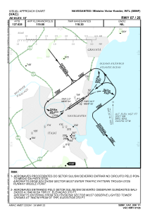
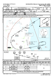
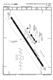
Runways:
| RWY identifier | QFU | Length (ft) | Width (ft) | Surface | LDA (ft) |
| 07 | 56° | 1821 | 280 | ASPH | |
| 25 | 236° | 1821 | 280 | ASPH |
Airport contact information
Address: Navegantes / Ministro Victor Konder Brazil