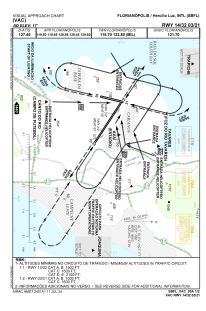
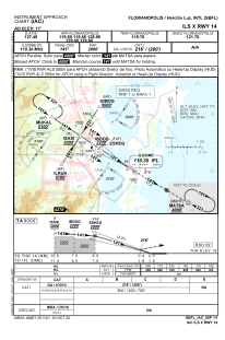
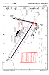


SBFL - Florianópolis / Hercílio Luz
Located in Florianópolis / Hercílio Luz, Brazil
ICAO - SBFL, IATA - FLN
Data provided by AirmateGeneral information
Coordinates: S27°40'13" W48°33'9"
Elevation is 16 feet MSL.
Magnetic variation is -20.0° East View others Airports in Santa Catarina
Operational data
Special qualification required
Current time UTC:
Current local time:
Weather
METAR: SBFL 271400Z 35018KT CAVOK 26/22 Q1010
TAF: TAF SBFL 270900Z 2712/2812 33015KT 9999 SCT020 TX28/2715Z TN21/2809Z BECMG 2714/2716 03018KT FEW035 BECMG 2722/2724 35010KT BECMG 2804/2806 18018KT SCT035 RMK PFF
Communications frequencies: [VIEW]
Runways:
| RWY identifier | QFU | Length (ft) | Width (ft) | Surface | LDA (ft) |
| 03 | 12° | 1440 | 80 | CONC | |
| 21 | 192° | 1440 | 80 | CONC | |
| 14 | 121° | 2520 | 280 | ASPH | |
| 32 | 301° | 2520 | 280 | ASPH |
Airport contact information
Address: Florianópolis / Hercílio Luz Brazil