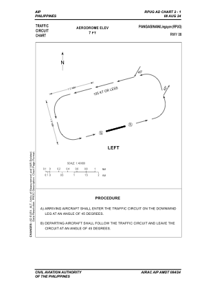


RPUG - Lingayen Community Airport
Located in Lingayen, Philippines
ICAO - RPUG, IATA -
Data provided by AirmateGeneral information
Coordinates: N16°2'4" E120°14'48"
Elevation is 6 feet MSL.
Magnetic variation is -3° East View others Airports in Pangasinan
Operational data
Special qualification required
Current time UTC:
Current local time:
Communications frequencies: [VIEW]
Runways:
| RWY identifier | QFU | Length (ft) | Width (ft) | Surface | LDA (ft) |
| 08 | 74° | 2625 | 98 | ASPH | 2625 |
| 26 | 254° | 2625 | 98 | ASPH | 2625 |
Airport contact information
Address: Lingayen Philippines