


PHNL - Daniel K Inouye Intl
Located in Honolulu,
ICAO - HNL, IATA - HNL
Data provided by AirmateGeneral information
Coordinates: N21°19'4" W157°55'13"
Elevation is 13 feet MSL.
Magnetic variation is 11° East View others Airports in Hawaii
Operational data
Special qualification required
Current time UTC:
Current local time:
Weather
METAR: PHNL 200253Z 07015G23KT 10SM FEW027 SCT035 BKN065 26/16 A3006 RMK AO2 SLP178 T02560161 55006
TAF: PHNL 192320Z 2000/2106 08014G25KT P6SM FEW025 SCT045 FM200400 06011KT P6SM VCSH SCT025 BKN045 FM202000 05010G20KT P6SM FEW025 SCT045
Communications frequencies: [VIEW]
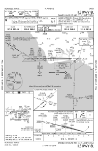
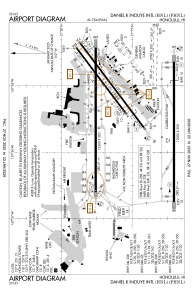
Runways:
| RWY identifier | QFU | Length (ft) | Width (ft) | Surface | LDA (ft) |
| 04L | 53° | 6955 | 150 | ASPH | 6952 |
| 22R | 233° | 6955 | 150 | ASPH | 6952 |
| 04R | 53° | 9002 | 150 | ASPH | 8950 |
| 22L | 233° | 9002 | 150 | ASPH | 8937 |
| 04W | 51° | 3000 | 150 | WATER | |
| 22W | 231° | 3000 | 150 | WATER | |
| 08L | 89° | 12312 | 150 | ASPH | 12312 |
| 26R | 270° | 12312 | 150 | ASPH | 12300 |
| 08R | 90° | 12000 | 200 | ASPH | 12000 |
| 26L | 270° | 12000 | 200 | ASPH | 12000 |
| 08W | 91° | 5090 | 300 | WATER | |
| 26W | 271° | 5090 | 300 | WATER |
Airport contact information
Address: Honolulu
Other aviation service providers
Repair station

Flight schools

Mauna Loa Helicopters | Hawaii Pacific Aviation
Mauna Loa Helicopters | Hawaii Pacific Aviation
info@maunaloahelicopters.com8088346799