


PHDH - Dillingham Airfield
Located in Mokuleia,
ICAO - HDH, IATA - HDH
Data provided by AirmateGeneral information
Coordinates: N21°34'46" W158°11'50"
Elevation is 14 feet MSL.
Magnetic variation is 11° East View others Airports in Hawaii
Operational data
Special qualification required
Current time UTC:
Current local time:
Weather at : PHHI - Wheeler Aaf ( 20 km )
METAR: PHHI 200855Z AUTO 32004KT 10SM FEW010 FEW022 SCT036 SCT045 OVC060 20/17 A3016 RMK AO2 DZB40E49 SLP205 P0000 60000 T02010169 51011 $
TAF: TAF PHHI 200700Z 2007/2113 VRB06KT 9999 SCT020 BKN025 QNH3011INS TEMPO 2012/2018 8000 -RA BKN020 BECMG 2017/2018 06009KT 9999 SCT030 BKN035 QNH3009INS TEMPO 2022/2104 07012G18KT BECMG 2105/2106 VRB06KT 9999 SCT020 BKN025 QNH3013INS TX25/2023Z TN19/2015Z LAST NO AMDS AFT 2008 NEXT 2215
Communications frequencies: [VIEW]
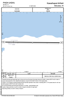
Runways:
| RWY identifier | QFU | Length (ft) | Width (ft) | Surface | LDA (ft) |
| 08 | 91° | 9007 | 75 | ASPH | |
| 26 | 271° | 9007 | 75 | ASPH |
Airport contact information
Address: Mokuleia
