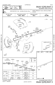


PFAL - Allakaket
Located in Allakaket,
ICAO - 6A8, IATA - AET
Data provided by AirmateGeneral information
Coordinates: N66°33'7" W152°37'20"
Elevation is 441 feet MSL.
Magnetic variation is 22° East View others Airports in Alaska
Operational data
Special qualification required
Current time UTC:
Current local time:
Weather at : PABT - Bettles ( 63 km )
METAR: PABT 282253Z 17003KT 10SM FEW050 04/M08 A2992 RMK SLP144 T00391078
TAF: PABT 282320Z 2900/2924 23005KT P6SM FEW050 SCT110 FM290600 VRB03KT P6SM BKN100
Communications frequencies: [VIEW]
Runways:
| RWY identifier | QFU | Length (ft) | Width (ft) | Surface | LDA (ft) |
| 05 | 73° | 4000 | 100 | GRAVEL | |
| 23 | 253° | 4000 | 100 | GRAVEL |
Airport contact information
Address: Allakaket