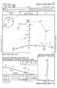
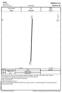


PATL - Tatalina Lrrs
Located in Takotna,
ICAO - TLJ, IATA - TLJ
Data provided by AirmateGeneral information
Coordinates: N62°53'42" W155°58'41"
Elevation is 933 feet MSL.
Magnetic variation is 22° East View others Airports in Alaska
Operational data
Special qualification required
Current time UTC:
Current local time:
Weather
METAR: PATL 251155Z AUTO VRB04KT 10SM OVC085 03/M01 A2986 RMK AO2 SLP119 T00341007 10085 20034 52009
Communications frequencies: [VIEW]
Runways:
| RWY identifier | QFU | Length (ft) | Width (ft) | Surface | LDA (ft) |
| 17 | 182° | 3820 | 150 | GRAVEL | |
| 35 | 2° | 3820 | 150 | GRAVEL |
Airport contact information
Address: Takotna