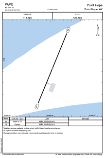


PAPO - Point Hope
Located in Point Hope,
ICAO - PHO, IATA - PHO
Data provided by AirmateGeneral information
Coordinates: N68°20'56" W166°47'57"
Elevation is 20 feet MSL.
Magnetic variation is 11° East View others Airports in Alaska
Operational data
Special qualification required
Current time UTC:
Current local time:
Weather
METAR: PAPO 251556Z AUTO 06004KT 10SM OVC034 01/M01 A2987 RMK AO2 UPE21 SLP113 P0000 T00061006 FZRANO
Communications frequencies: [VIEW]
Runways:
| RWY identifier | QFU | Length (ft) | Width (ft) | Surface | LDA (ft) |
| 01 | 22° | 3992 | 75 | ASPH | |
| 19 | 202° | 3992 | 75 | ASPH |
Airport contact information
Address: Point Hope