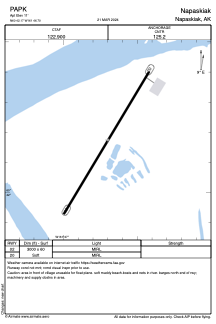


PAPK - Napaskiak
Located in Napaskiak,
ICAO - PKA, IATA - PKA
Data provided by AirmateGeneral information
Coordinates: N60°42'10" W161°46'42"
Elevation is 11 feet MSL.
Magnetic variation is 15° East View others Airports in Alaska
Operational data
Special qualification required
Current time UTC:
Current local time:
Weather at : PABE - Bethel ( 9 km )
METAR: PABE 261543Z 03005KT 10SM SCT001 SCT120 M02/M02 A2979 RMK AO2 T10221022
TAF: PABE 261256Z 2613/2712 07004KT P6SM BKN050 FM261900 02010KT P6SM OVC050
Communications frequencies: [VIEW]
Runways:
| RWY identifier | QFU | Length (ft) | Width (ft) | Surface | LDA (ft) |
| 02 | 31° | 3000 | 60 | GRAVEL | |
| 20 | 211° | 3000 | 60 | GRAVEL |
Airport contact information
Address: Napaskiak