


PANO - Nondalton
Located in Nondalton,
ICAO - 5NN, IATA -
Data provided by AirmateGeneral information
Coordinates: N59°58'49" W154°50'21"
Elevation is 314 feet MSL.
Magnetic variation is 14° East View others Airports in Alaska
Operational data
Special qualification required
Current time UTC:
Current local time:
Weather at : PAIL - Iliamna ( 25 km )
METAR: PAIL 290553Z AUTO 25011KT 10SM BKN130 04/01 A2991 RMK AO2 SLP130 T00390011 10106 20039 53020 TSNO $
TAF: PAIL 290536Z 2906/3006 24006KT P6SM BKN100 TEMPO 2906/2910 24012G22KT
Communications frequencies: [VIEW]
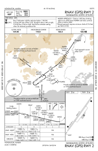
Runways:
| RWY identifier | QFU | Length (ft) | Width (ft) | Surface | LDA (ft) |
| 02 | 38° | 2800 | 75 | GRAVEL | |
| 20 | 218° | 2800 | 75 | GRAVEL |
Airport contact information
Address: Nondalton