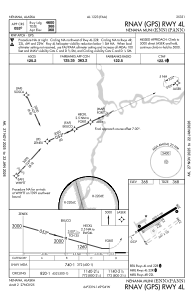
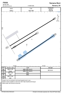


PANN - Nenana Muni
Located in Nenana,
ICAO - ENN, IATA - ENN
Data provided by AirmateGeneral information
Coordinates: N64°32'50" W149°4'26"
Elevation is 368 feet MSL.
Magnetic variation is 21° East View others Airports in Alaska
Operational data
Special qualification required
Current time UTC:
Current local time:
Communications frequencies: [VIEW]
Runways:
| RWY identifier | QFU | Length (ft) | Width (ft) | Surface | LDA (ft) |
| 04R | 59° | 1980 | 80 | GRASS | |
| 22L | 239° | 1980 | 80 | GRASS | |
| 04L | 59° | 4600 | 100 | ASPH | |
| 22R | 239° | 4600 | 100 | ASPH | |
| 04W | 56° | 3601 | 100 | WATER | |
| 22W | 236° | 3601 | 100 | WATER |
Airport contact information
Address: Nenana