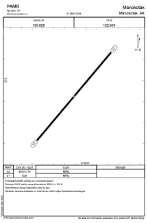


PAMB - Manokotak
Located in Manokotak,
ICAO - MBA, IATA - KMO
Data provided by AirmateGeneral information
Coordinates: N58°55'55" W158°54'7"
Elevation is 107 feet MSL.
Magnetic variation is 16° East View others Airports in Alaska
Operational data
Special qualification required
Current time UTC:
Current local time:
Weather
METAR: PAMB 231556Z AUTO 06010KT 9SM 01/00 A2982 RMK AO2 SLP102 T00060000 FZRANO $
Communications frequencies: [VIEW]
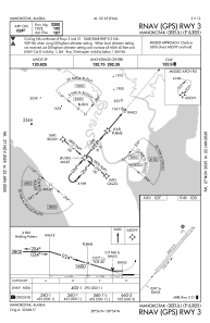
Runways:
| RWY identifier | QFU | Length (ft) | Width (ft) | Surface | LDA (ft) |
| 03 | 40° | 3300 | 75 | GRAVEL | |
| 21 | 220° | 3300 | 75 | GRAVEL |
Airport contact information
Address: Manokotak