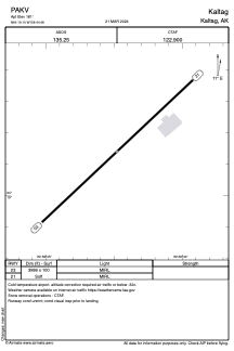


PAKV - Kaltag
Located in Kaltag,
ICAO - KAL, IATA - KAL
Data provided by AirmateGeneral information
Coordinates: N64°19'8" W158°44'29"
Elevation is 181 feet MSL.
Magnetic variation is 18° East View others Airports in Alaska
Operational data
Special qualification required
Current time UTC:
Current local time:
Weather
METAR: PAKV 200153Z AUTO 04003KT 10SM OVC080 07/M03 A3003 RMK AO2 SLP171 T00671033 TSNO $
Communications frequencies: [VIEW]
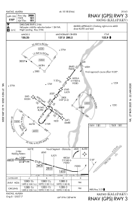
Runways:
| RWY identifier | QFU | Length (ft) | Width (ft) | Surface | LDA (ft) |
| 03 | 47° | 3986 | 100 | GRAVEL | |
| 21 | 227° | 3986 | 100 | GRAVEL |
Airport contact information
Address: Kaltag