


PAKT - Ketchikan Intl
Located in Ketchikan,
ICAO - KTN, IATA - KTN
Data provided by AirmateGeneral information
Coordinates: N55°21'15" W131°42'40"
Elevation is 92 feet MSL.
Magnetic variation is 21° East View others Airports in Alaska
Operational data
Special qualification required
Current time UTC:
Current local time:
Weather
TAF: PAKT 251734Z 2518/2618 32006KT P6SM SCT026 BKN035 FM252000 32010KT P6SM SCT070 FM260400 31003KT P6SM SKC FM261600 32008KT P6SM SCT120 AMD LTD TO CLD VIS AND WIND 2606/2615
Communications frequencies: [VIEW]
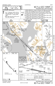
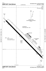
Runways:
| RWY identifier | QFU | Length (ft) | Width (ft) | Surface | LDA (ft) |
| 11 | 136° | 7500 | 150 | ASPH | |
| 29 | 316° | 7500 | 150 | ASPH | |
| WNW | 0° | 9500 | 1500 | WATER | |
| ESE | 0° | 9500 | 1500 | WATER |
Airport contact information
Address: Ketchikan