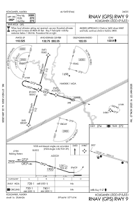


PAJZ - Koliganek
Located in Koliganek,
ICAO - JZZ, IATA - KGK
Data provided by AirmateGeneral information
Coordinates: N59°43'36" W157°15'37"
Elevation is 272 feet MSL.
Magnetic variation is 13° East View others Airports in Alaska
Operational data
Special qualification required
Current time UTC:
Current local time:
Weather
METAR: PAJZ 232056Z AUTO 12016KT 10SM CLR 07/02 A2988 RMK AO2 SLP124 T00720017 58006 $
Communications frequencies: [VIEW]
Runways:
| RWY identifier | QFU | Length (ft) | Width (ft) | Surface | LDA (ft) |
| 09 | 106° | 3300 | 75 | GRAVEL | 3300 |
| 27 | 286° | 3300 | 75 | GRAVEL | 3300 |
Airport contact information
Address: Koliganek