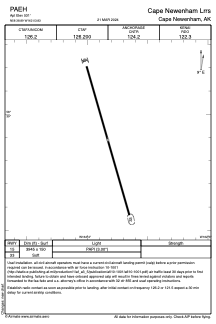


PAEH - Cape Newenham Lrrs
Located in Cape Newenham,
ICAO - EHM, IATA - EHM
Data provided by AirmateGeneral information
Coordinates: N58°38'53" W162°3'50"
Elevation is 531 feet MSL.
Magnetic variation is 12° East View others Airports in Alaska
Operational data
Special qualification required
Current time UTC:
Current local time:
Weather
METAR: PAEH 201255Z AUTO 02026G33KT 1/2SM -SHSN FZFG BKN002 00/ A2973 RMK AO2 PK WND 01037/1234 SHRAB1135E1242SHSNB1239 SLP075 P0000 T0001
Communications frequencies: [VIEW]
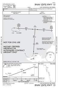
Runways:
| RWY identifier | QFU | Length (ft) | Width (ft) | Surface | LDA (ft) |
| 15 | 0° | 3945 | 150 | GRAVEL | |
| 33 | 0° | 3945 | 150 | GRAVEL |
Airport contact information
Address: Cape Newenham